Writing Task 1 Map | Đề bài, bài mẫu, từ vựng bài thi Writing Task 1 dạng Map
Bài mẫu Writing Task 1 Map – Bài số 01
1. Đề bài
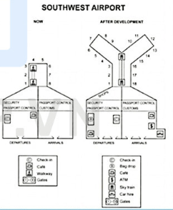
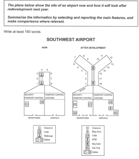
The plans below show the site of an airport now and how it will look after redevelopment next year. Summarise the information by selecting and reporting the main features, and make comparisons where relevant.
2. Bài mẫu Writing Task 1 Map: South West Airport
The maps depict an airport’s current layout as well as the planned layout for its redevelopment next year. Overall, it is clear that the airport will be expanded in terms of both amenities and space. There is currently a departure lounge to the west and an arrivals lounge to the east. Travelers can either visit the café opposite the check-in counter or proceed directly to passport control after checking in at the departures lounge as well as security zones. Beyond the airport’s northern boundary is a waiting room with a walkway and 8 gates to the runway. Arriving passengers must pass through this room before exiting the arrivals lounge to reach the passport control and customs areas.
Next year, many changes are expected to be seen following the airport’s redevelopment. Inside the departures lounge, the check-in counter will be moved closer to the center of the building, opposite newly-introduced bag drop and the café, which will be relocated southwest. Additionally, shops will be established in the airport’s midsection for travelers to visit before arriving at the Y-shaped waiting room with 18 gates and a sky train to transport passengers. Meanwhile, the arrivals lounge will featureacafé, an ATM and a car hire in an expanded section of the east wall. It is also notable that there will be one more entryway for each of the lounges.
Bài mẫu Writing Task 1 Map – Bài số 02
1. Đề bài
You should spend about 20 minutes on this task.
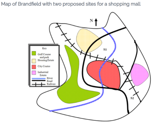
Below is a map of the city of Brandfield. City planners have decided to build a new shopping mall for the area, and two sites, S1 and S2 have been proposed.
Summarize the information by selecting and reporting the main features and make comparisons where relevant.
Write at least 150 words.
2. Bài mẫu
The map illustrates plans for two possible sites for a shopping mall in the city of Brandfield. It can be seen that the two sites under consideration are in the north and the south east of the town.
The first possible site for the shopping mall, S1, is just north of the city centre, above the railway line, which runs from the south east of the city to the north west. If it is built here, it will be next to a large housing estate, thus providing easy access for those living on the estate and in the city centre. It will also be next to the river that runs through the town.
The site in the south east, S2, is again just by the railway line and fairly close to the city centre, but it is near to an industrial estate rather than housing.
There is a main road that runs through the city and is close to both sites, thus providing good road access to either location. A large golf course and park in the west of the town prevents this area from being available as a site.
Bài mẫu Writing Task 1 Map – Bài số 03
1. Đề bài
You should spend about 20 minutes on this task.
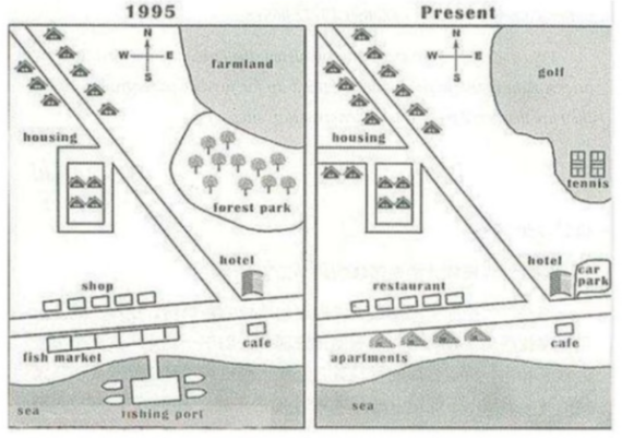
The map below shows the development of the village of Ryemouth between 1995 and present.
Summarize the information by selecting and reporting the main features and make comparisons where relevant.
Write at least 150 words.
2. Bài mẫu
The map shows how a village called Ryemouth has developed over the last twenty-five years. There have been several changes, the most noticeable being the increases in accommodation, the elimination of the fishing industry, and the introduction of sports facilities.
In 1995, to the south of the village where the sea is there was previously a fishing industry, with a fishing port and quite a large fish market as well. Next to this was a small cafe. On the other side of the road running by the sea stood a line of five shops and a hotel, while situated in the north east part of the village was farmland and a park with trees. The main housing of the village was located in the north west around a main road that runs from the coastal road, with twelve houses, four of them encircled by a smaller side-street.
Turning to the present day map, it can be seen that the fishing facilities have all gone, being replaced by four apartments, and the shops have become restaurants. The cafe remains, as does the hotel, albeit with parking facilities which it did not have before. Having been converted into a golf course, the farmland has now gone, while the forest park has been removed to make way for tennis courts. Although the old houses remain, new ones have been built, along with a new road with two new houses beside it.
Bài mẫu Writing Task 1 Map – Bài số 04
You should spend about 20 minutes on this task.
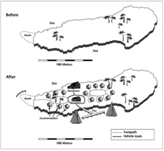
The two maps below show an island, before and after the construction of some tourist facilities.
Summarize the information by selecting and reporting the main features and make comparisons where relevant.
Write at least 150 words.
Bài làm mẫu:
The maps illustrate the changes that have occurred on an island due to the building of facilities for tourists.
The island originally consisted of just palm trees and the beach, yet now, although the palm trees remain, it hosts a wealth of attractions for holiday makers, from restaurants and swimming to accommodation.
The island is approximately 200 metres long, with a small beach on the western tip. It was deserted before, with only a scattering of palm trees. Now though, there is an abundance of places to stay in the form of fifteen beach huts situated in circular patterns in the centre of the island and to the west.
Between these two sets of accommodation there is also a new large restaurant and a reception building, both served by new vehicle tracks. Situated in the south is a t-shaped pier for ships to dock, and sailing boats are now evident in this area of the sea. Footpaths have also been constructed, which traverse the island, leading to the new buildings and also the beach, where tourists can now swim.
Bài mẫu Writing Task 1 Map – Bài số 05
The two maps below show a small village in the west of Ireland in the year 2000 and at the present time. Summarise the information by selecting and reporting the main features, and make comparisons where relevant.
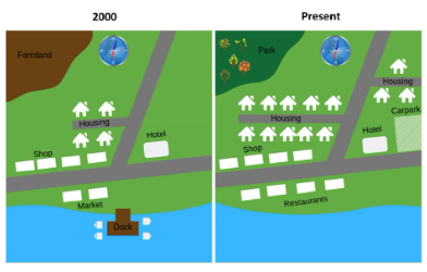
The maps illustrate how an Irish village has developed since 2000.
Overall, the village has changed considerably to become a more crowded residential area. Some new amenities, such as a park and a car park, have also been added.
In the north-west of the village, the farmland has been flattened in order to make way for a new park. The small road west of the main road, which runs in the north-south direction, has been extended further westward and more residential houses have been built along both its sides. In addition, another new small road has been built east of this main road in the north-east of the village, and some residential houses have also been constructed along it.
In the south of the village, the dock on the water has been demolished, and the marketsnext to the road running in east-west direction have been knocked down, and some restaurants have been erected in their place. On In the opposite side of this road, the shops and the hotel remain unchanged. However, a carpark has been added next to the hotel.
Bài mẫu Writing Task 1 Map – Bài số 06
Bài mẫu
The two plans show Southwest Airport as it is now and redevelopment plans for next year. Overall, the number of gates will increase significantly, while the main building will generally remain unchanged apart from the addition of more passenger facilities.
The current airport has very few facilities for departing passengers, with only a coffee shop on the right-hand side, opposite a check-in counter. There are no facilities beyond passport control and security, and passengers have to walk to the eight departure gates. Arriving passengers have no amenities at all.
Following redevelopment, both arriving and departing visitors are better catered for, beginning with double the number of entrances and exits. In the departures area, the coffee shop will move to the opposite side, closer to the front, and the check-in desk will take its place, making room for a new baggage drop counter. Although the security area will not change, beyond this section, passengers will be able to shop and can use the new sky train service to reach the expanded gate area, with ten additional gates. Arriving passengers will also have access to a coffee shop and a currency exchange. The only structural change to the main building is a small annexe in the front right-hand corner, where passengers will be able to hire a car.
Bài mẫu Writing Task 1 Map – Bài số 07
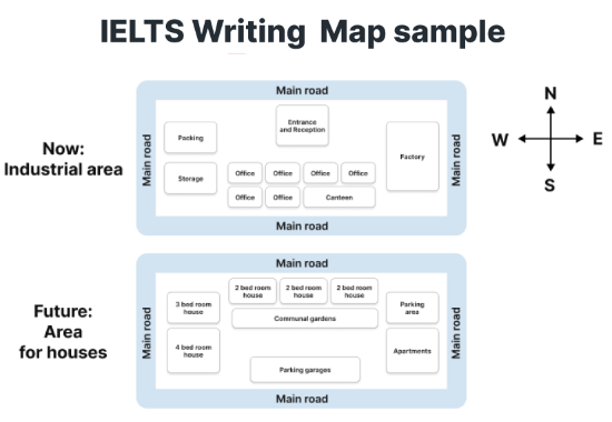
The maps show how the industrial area will change into a housing area in the future.
Bài mẫu:
The given table illustrates certain forecasted alternations in an industrial site, which will be transformed into residential areas in the future.
Overall, the most noticeable changes will be the addition of various buildings to the North and East of the spot; also the modification of names of specific areas and their facilities will be recorded.
Regarding the East side of this place, the factory is predicted to be replaced by apartments, which will be located next to the newly-added parking area. While the current Entrance and Reception are placed to the North, the plan proposes its substitution by residential areas including 6 bedroom houses which will be accessed through communal gardens.
Significant changes will also be projected on the remaining sides of this site. The 3 bedrooms house and 4 bedroom house will replace the packing and storage areas in the Western part. Additionally, the substitution of offices and canteen for parking garages is also suggested in this plan.The only feature that is predicted to remain its original position is the main road which surrounds the whole area.
Bài mẫu Writing Task 1 Map – Bài số 08
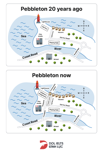
The plan below shows the village of Pebbleton 20 years ago and now.
Mẫu:
Overall, it can be seen that the most noticeable change was the addition of houses and other facilities such as footbridge, tennis court, community center as well as the replacement of old fort with a children’s playground.
Specifically, on the western side of the city, while the lighthouse has not changed its initial position for 20 years, the substitution of the old fort with a children’s playground and the film studio with flats has been recorded. At present, a footbridge has been built to connect the coast road to the old fort road, which greatly assisted students of the school in the south to cross the river. There was a footpath at the end of the footbridge and a tennis court was added in the middle of the footpath and the lighthouse land.
Towards the north of the map, the number of houses increased and the city had a new community center located near the residential area. Regarding the eastern side, almost every feature such as the old fort road, the playing field and the roadbridge remained unchanged.
Xem thêm các tài liệu Tiếng Anh hay, chi tiết khác:
TOP Việc làm "HOT" dành cho sinh viên:


